
Museum-quality posters made on thick and durable matte paper. Shipped in a reinforced package.

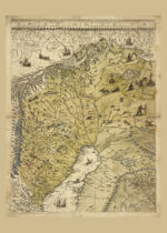
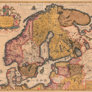
Historical map of northern Sweden 1626
Historical map of northern Sweden 1626
Price range: $23.00 through $29.00
Reprint of a historical map of the Swedish provinces Norrbotten, Västerbotten and Lappland. The original was published in 1626 in the cartographer Anders Bure’s work “Orbis Arctoi nova et accurata delineatio” which covered the entire kingdom. The map shows Norrbotten, Västerbotten and Lappland, as well as parts of Norway, Finland, Jämtland, Ångermanland and Medelpad. The map is very detailed and shows ships, boats, hunting and cabins and more. Available in several sizes.
Additional information
| Weight | N/A |
|---|---|
| Size | 40×60 cm / 16×24″, 50×70 cm / 20×28″, 60×90 cm / 24×36″ |
Related products
-
 Price range: $19.00 through $27.00 Select options This product has multiple variants. The options may be chosen on the product page
 -
 Price range: $19.00 through $29.00 Select options This product has multiple variants. The options may be chosen on the product page
 -
 $32.00 Select options This product has multiple variants. The options may be chosen on the product page
 -
Denmark, Finland, Norway, Sweden
Price range: $26.00 through $29.00 Select options This product has multiple variants. The options may be chosen on the product page